Introduction
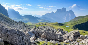
The Dolomites, a UNESCO World Heritage site, rank among the most dramatic mountain ranges in Europe. Narrow limestone ridges, spiky pinnacles, alpine meadows and crystal-clear high-altitude lakes create a scene that looks ripped from a romantic painting. For hikers, this landscape offers exceptional variety: easy panoramic walks for families, technical via ferratas, long high-altitude traverses and early-morning summits for sunrise. This article lists the top 10 hikes you shouldn’t miss in the Dolomites, with practical details (exact addresses, fees, opening hours), vivid descriptions and local tips to get the most out of each route.
Whether you’re heading out for a gentle lakeside stroll or a full day’s push up to a perched rifugio, preparation is key: pack the right gear, check the weather, note cable car and rifugio timetables, and stick to the trails. We include precise locations (start points, parking, mountain huts), current prices for lifts and access where available, and typical opening hours so you can plan without surprises. The hikes cover different areas of the Dolomites — Cortina d’Ampezzo, Alta Badia, Val Gardena, Val di Funes, Val di Fassa and other picturesque valleys — giving you a broad palette of experiences.
This guide also aims to immerse you in the local atmosphere: the scent of rhododendron, the ring of crampons on via ferrata pegs, shepherds leading their flocks, and mountain huts serving hearty Tyrolean fare. You’ll find practical tips on the best times of day for photos, bad-weather alternatives, public and private transport options, and accommodation recommendations near trailheads. Each section includes visual cues and image markers to help you picture the panoramas before you see them in person.
Ready to lace up your boots? Grab a windproof jacket, fill your water bottle, check your maps and join us across the Dolomites’ most iconic summits. The routes suit a range of levels; descriptions note difficulty and alternatives. We start with one of the most emblematic hikes and then explore other trails that together create an unforgettable itinerary through these bewitching mountains.

Tre Cime di Lavaredo (The Three Peaks) — Classic Circuit and Mountain Huts
The hike around the Tre Cime di Lavaredo is perhaps the Dolomites’ most famous route. The three towers — Cima Grande, Cima Ovest and Cima Piccola — rise like stone cathedrals above a rocky amphitheatre. The classic route is a loop starting from Rifugio Auronzo parking and circles the peaks, passing the Auronzo, Lavaredo and Locatelli mountain huts.
Main route
Start point: Rifugio Auronzo parking, exact address: Strada Statale 48, 39030 Misurina (Belluno), Italy. Approx GPS: 46.5976 N, 12.2597 E. Parking fee: around €12 to €30 depending on season (paid, monitored). Hours: the parking is accessible 24/7 but the hut and shop usually open from 07:00 to 19:00 in high season (May–October).
The full loop is roughly 10–12 km with about 400–600 m of ascent depending on the variant. Allow 3 to 5 hours at a moderate pace. The trail is well marked (red rings and plaques) and offers spectacular views at every turn. On the southern side, Rifugio Auronzo (Rifugio Auronzo) is located at Strada Statale 48, 39030 Misurina. Phone: +39 0435 901047. It serves typical dishes and dorm-style beds; approximate prices: lunch €12–25, overnight in a dorm €30–50 per person depending on season.

Rifugio Locatelli (Rifugio Antonio Locatelli – Drei Zinnen Hütte) is located at: 39030 Sexten (Bolzano/Bozen). Phone: +39 0474 710294. Opening season: usually late May to early October, 08:00–20:00; check outside those months. Prices: coffee €3–5, daily dish €15–20, dorm bed €35–60 depending on comfort and season. From the hut the view of the north face of the Tre Cime is breathtaking, especially at sunset or during the blue hour when the cliffs take on a pink glow (alpenglow).
Practical tips: arrive early to avoid crowds and tour buses. Bring a windproof jacket even in summer — altitude and exposure can make the wind chilly. In autumn watch for the first snow and check conditions before you go. Dogs are allowed on leash and drinking water is available at the huts.
 Click here to book a guided hut tour of the Tre Cime
Lago di Braies and the Lakeside Trail — Family Walk and Kayaking
Lago di Braies (Pragser Wildsee in German) is an iconic alpine lake with emerald waters and wooded shores, making it a must-visit for an accessible and highly photogenic walk. The lakeside path is short but stunning and can be combined with climbs to nearby viewpoints for sweeping panoramas.
Practical information
Parking and start point: Lago di Braies parking, exact address: Via Lago di Braies, 39030 Braies (BZ), Italy. GPS: 46.6996 N, 12.0809 E. Parking fee: €10 to €25 depending on season and duration (paid). The lake is very popular, especially between 09:00 and 17:00 in summer; the best time is sunrise for tranquility and perfect photo light.
The lakeside loop is about 3.5 km and takes 1–1.5 hours on foot. For a different experience, wooden boat rentals are available: about €12 for 30 minutes. Refreshments and rentals: Ufficio Lago di Braies, usually open 08:00–18:00 in summer. There is no entrance fee for the lake, but parking is controlled and it’s strongly recommended to arrive early or use shuttles from nearby villages during high season.
Immersive description: picture a wooden boat gliding across a mirror-like surface with peaks reflected like a watercolor, the silence punctuated only by the dip of oars. Shores are fringed with pine forest and in summer wildflower trails. For broader views, follow paths toward Monte Specie or the viewpoint near Rifugio Biella.
Click here to book a yoga session and short hike
Local tips
- Arrive before 08:00 in high season to secure a parking spot; after 10:00 queues are common.
- Shuttle from Dobbiaco/Toblach: check local timetables (local tourist operators, fares vary €3–8).
- Be aware of photography restrictions during certain local events; respect nature and leave no litter.
- Nearby restaurants: Ristorante Lago di Braies, Via Lago di Braies 1, 39030 Braies, open 09:00–20:00; dishes €8–20.
Seceda and Val di Funes — Panoramic Ridges and Picture-Perfect Villages
Seceda, towering over Val Gardena and Val di Funes, offers airy ridgelines and rolling meadows dotted with flowered chalets. The classic ascent is from Ortisei (Urtijëi) via the Ortisei–Seceda cable car, or from Val di Funes for a wilder path.
Access and prices
Main access: Ortisei–Seceda cable car, departure station: Via Troier 39, 39046 Ortisei (BZ). Ticket office phone: +39 0471 777333 (Südtirol Ski/Alpe di Siusi). Summer cable car hours: typically 08:30–17:00 (periods vary by season). Approx round-trip fare: €30–€40 per adult (seasonal variations and local discounts apply).
For hikers wanting more exertion, you can walk up from the valley (starting villages like Santa Maddalena): marked trails with about 800–1,200 m of ascent depending on the starting point. Seceda’s meadows are perfect for sunrise panoramas with views embracing the Odle/Geisler group.
Click here to book an iconic day trip to Seceda and Lake Carezza

Experience and recommendations
The climb to Seceda is particularly memorable in spring and summer when rhododendrons and gorse bloom. Cowbells from grazing herds and ribbon-like trails along the ridge add a pastoral charm to the hike. For via ferrata enthusiasts, technical routes start near the Odle/Geisler sectors. Photographers will love the color palette at golden hour — pack a light tripod for long exposures at sunset.
Local tips: wear shoes with good grip for the ridge, bring a fleece and windproof (winds can be strong at the top). If you plan to sleep high, Rifugio Fermeda (Seceda area, bookings via the local ticket office, phone +39 0471 777333) offers hot meals and dorm accommodation. Book ahead in summer (overnight prices €30–60).
Sella Ronda and the Loop Around the Sella Massif — Hiking and Biking
The Sella Ronda is a well-known loop encircling the Sella massif, accessible on foot, by bike or by ski depending on the season. For hikers it provides high-altitude trails, passes and historic huts. You can cover sections in a day or plan a multi-day traverse linking refuges.
Start points and lifts
Access is possible from multiple valleys: Val di Fassa, Val Gardena, Alta Badia and Arabba. Example start: Pordoijoch / Passo Pordoi, address: Passo Pordoi, 32020 Passo Pordoi (TN). Passo Pordoi cable car (Funivia Passo Pordoi): departure Piazza Marmolada, 32020 Canazei, phone +39 0462 601133. Hours: typically 08:30–17:00 in summer. Cable car fare: about €15–€25 return depending on season.
The full loop on foot isn’t a single uniform trail like a long-distance trek, but you can link several passes (Passo Sella, Passo Pordoi, Passo Gardena) for a big day of hiking. Elevation gain varies greatly by route — bring local maps (Kompass, Tabacco). Typical huts along the way: Rifugio Forcella Pordoi, Rifugio Jimmy, Rifugio Boè — addresses and contacts vary; overnight rates €30–70 depending on comfort and season.
If you’re interested in the road itself, also check our guide to Passo Sella and its iconic views.
Click here to book a half-day Sellaronda

Tips for hikers and cyclists
- Check cable car and gondola timetables: they change outside high season and can close in bad weather.
- If you ride the loop by bike (MTB or gravel), expect technical sections and paid lifts for bikes (€15–25).
- Carry topo maps and a GPS; the terrain changes and some high routes may close early in spring.
- Book huts in advance in July–August; many fill up quickly.
Marmolada — Glacier, Cable Car and Historic Trail
Marmolada, the highest mountain in the Dolomites, is home to a glacier and a dramatic cable car from Malga Ciapela. It’s a place steeped in history (WWI front lines 1915–1918) with routes that blend geology, history and vertiginous views.
Access and useful info
Main start: Malga Ciapela, address: Via Dolomiti 33, 32022 Malga Ciapela (BL). Marmolada cable car info: +39 0437 641100. Cable car hours: typically 08:30–16:30 in summer (varies). Return fare: around €28–€35 per adult. From the summit you’ll find viewpoints over the glacier and historic footpaths (Ghiacciaio della Marmolada) with panels about World War I.
Immersive description: ride the cable car up to the Marmolada balcony for views over the ice cap and down into the valley. Winds can be strong and temperatures cold even in summer — bring warm layers. The mountain war museum (Museo della Grande Guerra) and ridge lines with old tunnels are rewarding for history buffs.
Practical tips
- Crossing the glacier requires proper gear and experience; local alpine guides offer safe guided trips.
- Check cable car operation and glacier conditions before you go (tel. +39 0437 641100).
- Plan lunch at Rifugio Punta Rocca (on the summit): dishes €12–20; opening hours vary by season.
Catinaccio (Rosengarten) and Alpe di Siusi — Flowered Traverses and Legends
The Catinaccio (Rosengarten) massif is famed for its glowing red faces at sunset and the legend of King Laurin. The area suits varied hikes, from walks across the Alpe di Siusi (Seiser Alm) to technical ascents toward Forcella delle Mesules.
Access to Alpe di Siusi and prices
Access point: Ortisei–Alpe di Siusi. Cable car address: Via Meisules 39, 39046 Ortisei (BZ). Alpe di Siusi cable car hours: typically 08:30–17:00; round-trip fare €28–€36 depending on season. The Alpe di Siusi offers vast meadows perfect for family hikes of 2–6 hours and great views of the Catinaccio massif.
Immersive description: in spring and summer the meadows turn into seas of wildflowers; wooden huts sell artisanal cheeses and mountain dishes. Trails wind between dolomite blocks, forests and alpine pastures; the scent of cut hay and warmed pine fills the air.
Recommended hike
A lovely option is the ascent to Rifugio Re Alberto / Berggasthof Molignon and the loop to Forcella delle Mesules. Hut address: località Molignon, 39046 Tires (BZ). Reservation phone: +39 0471 705286. Huts are usually open late May to October; meal prices €10–20, overnight €30–60.
Local tips: try the « Tirtlan » (a savory Tyrolean stuffed pancake) at a mountain hut; buy local cheese and speck for a picnic. Trails can be muddy after summer storms, so bring poles and sturdy boots.
Click here to book a photo session in Val Gardena or Alpe di Siusi

Conclusion
The Dolomites offer an astonishing variety of hiking experiences: peaceful strolls around emerald lakes, panoramic ascents along rugged ridges, high traverses with welcoming huts, and historic climbs over glaciers. The ten hikes covered here — Tre Cime di Lavaredo, Lago di Braies, Seceda, Sella Ronda, Marmolada, Catinaccio and Alpe di Siusi (with many local variants) — are just a starting point. By combining several routes you can build an itinerary ranging from a few hours’ walk to multi-day hut-to-hut adventures.
Before you set out always check current timetables and prices (figures here are seasonal estimates), get the latest trail conditions, monitor the weather and respect the mountain. Pack appropriate clothing, enough water, energy food, a first-aid kit and, for technical routes, the right equipment (helmet, via ferrata set, crampons if needed). Think about logistics too: book huts in advance, arrive early at popular parkings or use local shuttles to reduce car impact. Protecting the environment is essential: stay on marked trails, don’t pick alpine flora and carry out all your waste.
Finally, take the time to savor more than the views: mountain villages (Ortisei, Cortina d’Ampezzo, Canazei, Corvara), huts where stories are shared over warm meals, and local traditions (Tyrolean cuisine, woodcraft) will enrich your trip. The Dolomites charm photographers and artists as much as challenge-hungry hikers — every trail delivers unforgettable moments. Happy hiking and stay safe — the mountains reward respect with lasting memories.