Introduction
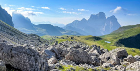
The Dolomites, a UNESCO World Heritage site, are famous for their jagged silhouettes, ochre spires and dramatic ridgelines that draw hikers, climbers and photographers from around the world. Walking a ridge in the Dolomites isn’t just about following a rocky crest: it’s about chasing the light, feeling the verticality of the faces, hearing the wind sculpt the clouds and discovering panoramas that change with every step. From airy, easy arêtes to technical ridges reserved for experienced alpinists, the range offers routes that blend geological beauty, First World War history, welcoming mountain huts and well-equipped via ferratas.
This article is a detailed guide to the most beautiful ridges to hike in the Dolomites. You’ll find immersive descriptions, exact addresses, approximate cable car or road fees, typical opening hours, plus practical local tips (gear, safety, seasons). Whether you want a panoramic ridge you can do in a day hike or a demanding alpine arête, the sections below will help you choose and prepare your outing. We cover iconic routes: the arêtes around the Tre Cime di Lavaredo, the Lagazuoi ridge, Seceda, Piz Boè and the Sella Group, the Marmolada, and more intimate sectors like Cinque Torri and the Tofana.
Each description includes: access (exact parking or cable car station address), indicative prices in euros, facility opening times, a detailed route and landscape overview, plus concrete advice on weather, safety, navigation and logistics (where to sleep, where to rent kit, useful phone numbers). The Dolomites are demanding mountains: the weather changes fast, summer storms can be violent and some ridges require specific gear and experience. Read the practical tips carefully before you go and, if in doubt, contact a local guide.
Throughout the text you’ll find visual cues to plan your photo shots: most photogenic times of day, prime viewpoints and suggested angles. We’ve added image markers for the most photogenic sections to help you visualize and prepare your camera gear. Finally, remember that practical information (prices, timetables, road access) can change: check official hut and cable-car websites before you set off. Enjoy the read and happy ridge-walking in the Dolomites!
Tre Cime di Lavaredo: the legendary ridge and the Kleine Zinne arête
The Tre Cime di Lavaredo (Tre Cime = Three Peaks) are the ultimate icon of the Dolomites. Located in the Tre Cime Natural Park, they offer a variety of ridges and arêtes, from straightforward panoramic traverses to demanding alpine terrain. The classic access point is Rifugio Auronzo, the starting place for the loop around the Three Peaks or for attempting more committing traverses such as the Kleine Zinne arête (Cima Ovest / Cima Piccola).
 Click here to discover the Tre Cime di Lavaredo circuit
Click here to visit the Tre Cime huts with a guide

Access: Rifugio Auronzo, Località Auronzo 3, 32041 Auronzo di Cadore (BL), Italy. The Rifugio Auronzo car park is reached via a private toll road from Misurina. Indicative road fee: around €30–35 per car (varies by season and year). Road access times: generally open from late May to late October (depending on snow), with vehicle passage usually allowed from 06:00 to 18:00 in high season; check the official Auronzo municipality site for exact dates.

Immersive description: From the Rifugio Auronzo car park the classic circuit around the Tre Cime follows well-marked trails and delivers jaw-dropping views of the towering north faces. Walking the peaks’ ridgeline, you encounter successive vertical sheets of pink dolomite, late snowfields and deeply carved gullies. The Cima Piccola arête is more technical: it requires rope, helmet and possibly friends for some rock sections. The exposed faces still bear traces of First World War history: tunnels and observation posts remind you of the fighting that took place on these high plateaus.
Recommended route and duration
- Classic Tre Cime loop (via Sentiero A. Innerkofler): 3.5–4.5 hours, 10–12 km, moderate elevation gain.
- Kleine Zinne/Cima Piccola arête (alpine climbing route): half-day to full day depending on options; rock climbing grade II–IV, decisions depend on conditions.
Practical tips: start early to beat the crowds and catch the soft morning light; bring warm layers even in summer (wind and sudden temperature drops are common). Key huts are Rifugio Auronzo (Località Auronzo 3, 32041 Auronzo di Cadore BL, tel. +39 0435 996, seasonal opening; breakfast/lunch/dinner; meals ~€12–25) and Rifugio Locatelli (Dreizinnenhütte) (Via delle Tre Cime, 32041 Auronzo di Cadore BL, tel. +39 0435 90926; hours vary by season). Check availability and book in high season.
Safety and regulations: stick to marked trails; some sections are exposed and require solid boots, trekking poles and a helmet if you tackle rocky arêtes. Dogs are allowed on most trails but must be kept on a leash. In case of emergency call the European mountain rescue number: 112 (or the Italian emergency number 118 for ambulance and rescue).
Lagazuoi and Passo Falzarego: historical ridge and WWI tunnels
The Lagazuoi massif overlooks Passo Falzarego and offers a ridge rich in history and sweeping views. The Monte Lagazuoi ridge is famous for its sightlines to the Cristallo monolith, the Tofane arêtes and the broad valleys below. Visitors can combine ridge walking with exploring the galleries and tunnels dug during the First World War, now arranged as an open-air museum.
Click here to book a guided hike to Lagazuoi

Access: Funivia Lagazuoi (Lagazuoi Cable Car), Passo Falzarego, 32043 Colle Santa Lucia (BL), Italy. Departure station: Passo Falzarego (parking near the Grand Hotel Falzarego). Useful address: Passo Falzarego, 32020 Livinallongo del Col di Lana (BL). Indicative cable car fare: round-trip €25–30 (seasonal variations and family discounts possible). Hours: typically 08:30–17:00 in summer with regular departures; check the official ticket office for exact times and closures.

Immersive description: The cable car ride up to the Lagazuoi station offers an immediate, spectacular panorama. At the top, the ridge stretches between soft arêtes and notches, with views of the Marmolada, the Cinque Torri and the Ampezzo valley. The summit trail is often stony, dotted with boulders and slabs; the traverse to Rifugio Lagazuoi (Via Lagazuoi) is breathtaking, especially at sunrise or sunset when the dolomite glows with golden hues.
Route, museum and huts
- Classic route: cable car from Passo Falzarego → Lagazuoi summit → descent via Sentiero 401/420 toward Forcella Lagazuoi or return to Passo Falzarego; duration: 2–4 h depending on stops.
- World War I museum: walk through the renovated tunnels and trenches (free access from the summit; guided tours may be available for a fee).
- Rifugio Lagazuoi (Rifugio Lagazuoi 2752 m): summit hut, phone +39 0436 870203 (seasonal opening); hot meals ~€10–20.
Practical tips: the tunnels can be damp and slippery; sticky-soled boots and a headlamp are useful. In summer bring sun protection and water (winds can dry you out fast). The exposed trail toward Forcella Lagazuoi requires caution in bad weather. Photographers will favor the golden hour at sunrise or sunset for dramatic contrasts.
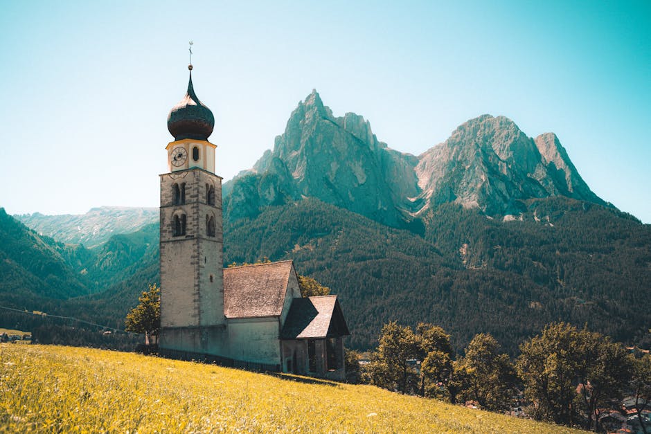
Seceda: Val Gardena’s airy ridge and sculpted panoramas
Seceda is one of the most photogenic ridges in the Dolomites, famed for its grassy arêtes and sheer cliffs dropping to the Val di Funes and the Odle/Geisler group. The Seceda silhouette is unmistakable: a pure line that tapers to offer sweeping viewpoints toward the Odle and the Puez-Odle plateau.
Access: Cabinovia Seceda / Funivia Seceda, departure station Piazza S. Antonio 2, 39046 Ortisei (St. Ulrich) BZ, Italy. The Ortisei cableway to Seceda via Saltria: indicative round-trip fare ~ €28–35 (varies by season). Hours: commonly 08:30–17:00/18:00 in summer; extended hours may apply during busy periods. Useful address for orientation: Piazza S. Antonio, 2, 39046 Ortisei (BZ).

Immersive description: The summit plateau of Seceda offers a grassy ridge that becomes a true lookout: on one side the towering rock giants of the Odle, on the other the green folds of Val Gardena. The terrain is less technical than many rocky arêtes but still requires care on exposed sections, especially when the grass is wet. Alpine meadows in spring are dotted with flowers, and in autumn the ridge turns shades of warm oranges and browns.
Click here to book a photo session in Val Gardena

Walks and variants
- Seceda – Rifugio Firenze – Col Renzler hike: 3–5 h, suitable for experienced day hikers.
- Traverse to Pieralongia / Furcia Rossa: longer, wilder routes for those seeking solitude.
- Huts: Rifugio Fermeda (Regole 3, 39046 Ortisei BZ, phone +39 0471 777… check locally) and other seasonal shelters offering drinks and snacks (beverage prices ~€3–7).
Practical tips: buy your cable car tickets online during peak times to avoid queues. Bring trekking poles, a windproof jacket and water — the route can feel easy but distances and altitude changes are tiring. Photographers will prize evening light with the Odle in the background.
Piz Boè and the Sella Group: wide ridges and 360° panoramas
Piz Boè (3,152 m) is the highest point of the Sella massif and a popular goal for long ridges with 360° views. The ridges around the Sella Group are perfect for extended high-mountain traverses: broad crests, inclined slabs and airy passages alternate with friendly huts where you can get a hot meal.
Access: several approaches are possible. A convenient option is Passo Pordoi (Strada statale 48 delle Dolomiti), a gateway to trails leading to Piz Boè via Col di Pordoi. Useful address: Passo Pordoi, 39036 Canazei (TN), Italy. Cable car: the Funivia Pordoi climbs from Passo Pordoi to Forcella Pordoi; indicative round-trip fare: €18–25. Hours: often 08:30–17:00 in season.
Click here to book a Great Dolomites tour at Pordoi
Immersive description: The ascent of Piz Boè typically includes an exposed final ridge but one that rewards with views of the Marmolada, the Pale di San Martino and the Sella massif. Terrain varies: scree slopes, slabby rock and occasional late snowfields. The Sella traverse — whether the ski Sella Ronda or the summer hiking version — reveals the scale of plateaus and arêtes.

Accommodation and meals
- Rifugio Boè (Rifugio Giorgio Costazza al Piz Boè): located at or near the summit; check seasonal availability; refuge nights ~€30–60 depending on comfort.
- Rifugio Franz Kostner (Rifugio Forcella Pordoi): near the Pordoi cable car; meals €12–20.
Practical tips: allow time to acclimatize to altitude. Afternoon storms can roll in quickly: start early, have a backup plan and pack a waterproof jacket. Use topographic maps (Tabacco 1:25,000) and an offline GPS app — mobile coverage can be patchy.
Marmolada: the icy ridge and the “Queen of the Dolomites”
The Marmolada, nicknamed the “Queen of the Dolomites,” hosts the largest glacier in the group and ridges that alternate rock and ice. The summit arête and approaches from the Malga Ciapela valley deliver classic high-mountain scenes with views over the glacier, seracs and deep valleys.

Access: Funivia Marmolada / Serauta Cable Car from Malga Ciapela, Località Malga Ciapela, 32020 Rocca Pietore (BL), Italy. Useful planning address: Località Malga Ciapela 2, 32020 Rocca Pietore BL. Indicative fare: round-trip ~€30–40 (varies by season and ticket type). Hours: typically 08:30–17:00 in summer; some facilities close out of season. Check cable car and Serauta station openings.
Immersive description: The cable car up to Serauta lets you appreciate the contrast between the glacier front and vertical walls. The summit arête leading toward Punta Penia (3,343 m) is a high-mountain route that involves glacier travel: crampons, ice axe and glacier-experience are mandatory. Panoramas include Val di Fassa, the Sella massif and — in clear weather — seemingly endless horizons.
Safety and regulations
- Mandatory glacier gear: crampons, ice axe, harness and rope if in a group; hire a certified mountain guide for glacier travel.
- Huts: Rifugio Pian dei Fiacconi (base at Malga Ciapela) for food and lodging; meals €10–25, accommodation €35–70 depending on services.
- Cable car hours change: check before you leave; access can be suspended in bad weather for safety.
Practical tips: do not attempt the icy ridge without experience or a guide. Crevasses are a real danger; the glacier’s position changes year to year with retreat. Book a local UIAGM/IFMGA guide if you’re not trained in glacier travel and rescue.
Cinque Torri and the Tofane: short ridges, big photos
If you’re after shorter ridges that are incredibly photogenic, Cinque Torri and the Tofana arêtes (especially Tofana di Rozes and Tofana di Mezzo) are perfect. They combine classic rock formations, historic routes and views over Cortina d’Ampezzo and the surrounding area.

Cinque Torri access: Passo Falzarego / Cortina d’Ampezzo. Useful address: Strada del Passo Falzarego, 32043 Cortina d’Ampezzo (BL). Parking is available near the base of Cinque Torri (small parking meters); access is often free or charged a small fee depending on season. Trail access: open 24 hours (unless temporary restrictions apply). Small war museums and seasonal huts are open mainly from June to September.
Click here to book a panoramic guided hike to the 5 Torri

Tofana access: Freccia nel Cielo cable car and lifts from Cortina d’Ampezzo. Cable car address: Corso Italia 53, 32043 Cortina d’Ampezzo (BL); indicative Freccia nel Cielo fare: €20–30 round-trip depending on destination. Hours vary by season, often 08:30–17:00.
Description and variants
- Cinque Torri: short arêtes and rock towers ideal for via ferrata, multi-pitch climbing and family hikes. Refuge Cinque Torri (Rifugio Scoiattoli): meals €10–20.
- Tofana di Rozes: more technical arêtes used by climbers and via ferrata (e.g. via ferrata Lipella/Tofana). The classic Rozes route requires rock experience; the via ferrata is accessible with the proper kit (harness, lanyards with energy absorber) for prepared hikers.
Practical tips: if you plan to climb or do a via ferrata, rent or buy certified kit (helmet, harness, lanyards) and check the equipment before every outing. In Cortina d’Ampezzo several mountain shops offer rentals (e.g. Sportservice Cortina, Corso Italia 59, 32043 Cortina d’Ampezzo BL; rental prices half-day €10–20, full day €20–35).
Local practical tips and safety for ridge hiking
The Dolomites offer a wide variety of routes, but several common rules apply to ensure safety and enjoyment. Here’s a detailed summary of local best practices before you tackle a ridge:
- Planning: check the weather (MeteoDolomiti, regional ARPA or local services). Avoid ridges in thunderstorms or fog. Summer storms often form in the afternoon: start early in the morning.
- Gear: sturdy mountain boots (Vibram or equivalent soles), trekking poles, helmet for rocky arêtes, windproof/waterproof jacket, water (at least 1.5–2 L per person for a day hike), energy snacks. For via ferrata and glaciers: full kit (helmet, harness, lanyards with energy absorber for via ferrata; crampons, ice axe and rope for glaciers).
- Local guides: if you lack the necessary experience, book a certified alpine guide (UIAGM/IFMGA). Guide offices: for example Guide Alpine Cortina, Corso Italia 45, 32043 Cortina d’Ampezzo (BL); prices vary by duration and difficulty (half-day €120–200, full day €200–350 for a group).
- Huts and accommodation: book in high season. Huts provide meals and dormitory sleeping; refuge nights ~€30–70 depending on comfort and season. Hut meal prices €10–25 for a hot meal.
- Transport and access: some access roads to huts (e.g. the road to Rifugio Auronzo) are toll roads: bring cash and cards. Cable cars have set schedules and may close for maintenance; always check official pages.
- Respect the environment: follow Leave No Trace: carry out your rubbish, protect fragile alpine flora and stay on marked trails.
- Emergencies: useful numbers in Italy: mountain rescue 112 (EU), ambulance 118; carry the precise location and GPS coordinates if possible to help rescuers.
Finally, match your ambitions to the season and your skill level. The Dolomites are beautifully demanding: prudence is rewarded with unforgettable panoramas and a deep sense of achievement.
Conclusion
Walking the ridges of the Dolomites means stepping into a world where geology, history and light combine to create landscapes unlike anywhere else. From the iconic silhouettes of the Tre Cime di Lavaredo to the icy arêtes of the Marmolada, through the grassy finesse of Seceda and the vastness of the Sella Group, each ridge tells a different story and offers its own emotions — sometimes contemplative, sometimes adrenaline-fueled. The huts scattered along routes add a human, welcoming dimension to these traverses: the comfort of a meal after a hard day, conversations with fellow hikers and the promise of a spectacular sunrise from a hut terrace.
On a practical level, prepare every outing carefully: check cable car fares and timetables (Rifugio Auronzo, Funivia Lagazuoi, Funivia Marmolada, Funivia Seceda and Funivia Pordoi), book huts during high season, bring the right equipment (helmet, harness/via ferrata kit, crampons/ice axe for the Marmolada) and, at the first doubt about your abilities, hire a certified local guide. Respect the weather, start early, protect the environment and always keep emergency numbers at hand.
Whether you’re after easy ridges for long panoramic hikes, technical arêtes for climbing, or dawn photo sessions, the Dolomites offer an endless palette of experiences. Take time to savor not only the summits but also the valleys, the huts and the hospitality of alpine villages: it’s the combination of all these elements that makes a Dolomite ridge hike truly unforgettable. Follow the recommendations in this article — addresses, access notes, practical details and safety tips — and you’ll be better prepared to fully enjoy the magic of the Dolomites’ ridges. Happy hiking and discoveries!