Introduction — Why hike the Alta Via in 7 days in the Dolomites
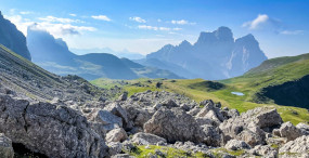
The Alta Via is more than just a mountain trail: it’s an immersive crossing through the heart of the Dolomites, a UNESCO World Heritage site, where every step reveals sculpted limestone walls, fragrant alpine meadows, surreal blue lakes and welcoming high-altitude refuges. Tackling the Alta Via in 7 days means keeping a brisk but achievable pace to hit the most iconic stretches — from the Tre Cime di Lavaredo to the Fanes forests, across airy passes and panoramic ridges. This condensed route requires solid preparation, but rewards you with an intense, spectacular alpine immersion.
In this day-by-day guide I’ll walk you through where to sleep, which scenic variants to favor, which waymarks to follow, which rifugi to book, and — most importantly — how to squeeze the most out of your experience (food, safety, weather, gear). You’ll find exact refuge addresses and useful locations, approximate timings and sample prices in euros for overnight stays, meals and transfers. These details make logistics easier: leaving a valley, catching a bus or taxi, booking a dorm bed or private room, or stocking up for a demanding day.
The route mixes technical stages with easier hiking sections; it’s aimed at fit hikers used to walking several hours a day carrying a pack between 8 and 12 kg. Italian rifugi are key stops: you’ll get a bed, a hot dinner and a friendly atmosphere — but know their opening times and capacities. This guide gives practical local tips, such as using the Dolomiti Mobilità pass for buses, the best periods to avoid crowds and afternoon storms, and tricks to handle altitude and cable-equipped sections.
Before you set off, check the local weather (MeteoDolomiti, ARPA Veneto), call rifugi to confirm availability and bring a paper map or GPS (GPX track of Alta Via 1 or Alta Via 2 depending on your route). Finally, keep the Dolomites mindset in mind: respect the environment, stay quiet at dawn to admire the pink sunrise on the cliffs (the « enrosadira ») and be curious about the Ladin culture of the valleys. Ready? Lace up and let’s start this magical crossing day by day.
 Click here to book a guided Tre Cime rifugio tour
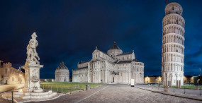
Day 1 — From Dobbiaco / Toblach to Rifugio Biella (or an approach stage to Tre Cime)
Most hikers start the Alta Via from the north at Dobbiaco/Toblach (station) to reach the Tre Cime di Lavaredo area quickly. Dobbiaco is reachable by train: Dobbiaco station, Piazza San Martino, 39034 Dobbiaco (BZ). If you arrive by car, park at the Parking Centro Civico, Via Münd, 39034 Dobbiaco — fees around €10–15 per day depending on the season. A typical first stage is the climb to Rifugio Biella (Rifugio Antonio Segagni Biella) or, for a more dramatic ascent, catch a bus up to Rifugio Auronzo.
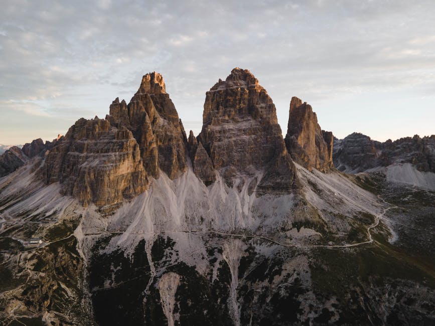
Rifugio Biella (at the foot of the Tre Cime) — Address: Loc. Forcella Lavaredo, 39030 Auronzo di Cadore (BL). Opening hours: generally open late June to mid-September, 08:00–20:00 (varies by season). Prices: dorm bed €25–40, half board €45–70, lunch €10–18. The refuge offers a direct view of the Tre Cime walls at sunrise — a must for photographers and hikers.
Suggested route: from Dobbiaco follow the bike path/trail to Misurina (about 12 km), then climb up toward Rifugio Auronzo via the SP49 (shuttles possible). Alternate: take the Dobbiaco–Tre Cime shuttle bus (Dolomiti Bus), fare roughly €2–5 depending on the zone. Approaching the Tre Cime the trail becomes rockier; bring poles and a headlamp for late arrivals.
Click here to book an airport transfer to Cortina d’Ampezzo
Practical tips: book your spot at Rifugio Biella or Auronzo at least 2–4 weeks ahead in high season (July–August). Carry an IGC « Cortina d’Ampezzo » 1:50 000 map or load the GPX track onto your phone. If an afternoon storm rolls in, wait it out at the refuge: summer storms can be frequent and intense.
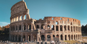
Day 2 — Tre Cime traverse to Rifugio Locatelli / Dreizinnenhütte
This stage is one of the most iconic: the trail circles the Tre Cime di Lavaredo and leads to Rifugio Locatelli (Dreizinnenhütte), perched at Forcella Langalm with outstanding views of the rock ridges. Rifugio Locatelli (Dreizinnenhütte) — Address: Sesto (Bolzano area), Loc. Langalm, 39030 San Candido (BZ). Opening hours: generally open June–September, 07:30–20:00; dinner and breakfast service available. Prices: dorm bed €28–45, private room €60–100, meals €15–25.
The hike often starts from Rifugio Auronzo (Rifugio Auronzo al Lavaredo, Address: Località Tre Cime, 32041 Auronzo di Cadore (BL), Opening hours: open throughout the tourist season; parking fees €30–35/day in high season). From Auronzo follow trails 101/105 that skirt the Tre Cime and reach the Forcella, then descend to Rifugio Locatelli. The walk is panoramic but includes exposed sections; hikers not used to exposed terrain should take care near ridge edges.
Click here to discover the Three Peaks of Lavaredo on a tour
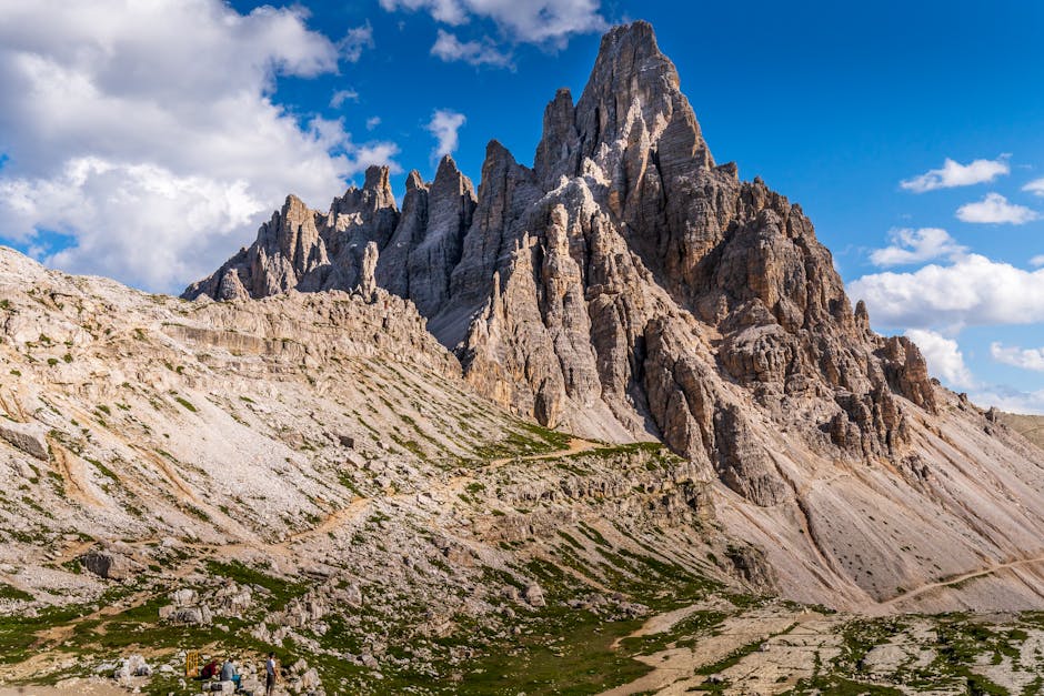
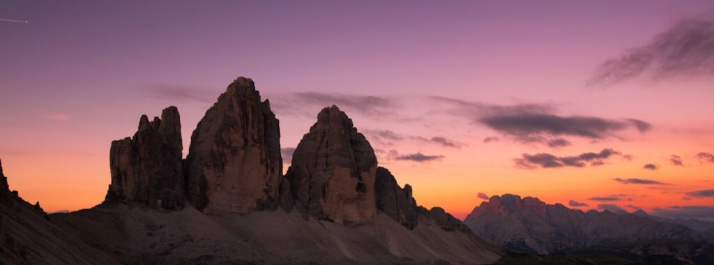
Immersive description: at sunrise the limestone faces turn a pink hue known as the « enrosadira. » You’ll cross scree fields, alpine meadows and talus slopes, with hollows where marmots and chamois may appear. Rifugio Locatelli has a terrace facing the Tre Cime — perfect for a late coffee and photos.
Local tips: carry a windproof and warm layers — temperatures drop quickly above 2,700 m. Book early if you want to sleep at Rifugio Locatelli — it’s hugely popular for its location. Refill your water bottle at the refuge: 1.5 L bottle about €3–4. For weather info contact the local ARPAV station or check the refuge information board.
Day 3 — Into the Fanes meadows: Rifugio Lagazuoi / Rifugio Fanes
Day three moves you from vertical cliffs to the wide Fanes plateaus. Depending on your chosen line (Alta Via 1 or variants), you may pass Rifugio Lagazuoi (accessed by cable car from Passo Falzarego) and then descend to the Fanes plateau. Rifugio Lagazuoi — Address: Passo Falzarego, 32020 Cortina d’Ampezzo (BL). Opening hours: Falzarego–Lagazuoi cable car roughly 08:00–17:00 (times vary), refuge open seasonally. Cable car price: return about €30–35.
Rifugio Fanes (Rifugio Fanes di Sopra) — Address: Località Fanes, 39030 San Vigilio di Marebbe (BZ). Opening hours: seasonally open, typically 07:30–21:00. Prices: night €30–55, half board €50–80. The route between Lagazuoi and Fanes crosses grassy cols, ridge paths and remnants of World War I (tunnels and trenches), offering a historical reading of the landscape.
Click here to book a guided Lagazuoi hike
Route and feel: if you take the cable car up to Lagazuoi, soak in the dramatic panorama over the peaks. The descent toward Fanes can be technical in places but rewards you with the calm of the meadows and the warm welcome of the rifugi. Fanes rifugi often serve Ladin specialties: canederli (dumplings), polenta and local cheeses — main dishes about €12–18.
Practical tips: to save energy, the Lagazuoi cable car can avoid a very steep climb — check its schedule with the Ski Area Falzarego office and carry ID for refuge check-in. Rifugi often prefer cash; mobile reception can be poor so bring some euros.
Day 4 — Crossing the Fanes plateau to Rifugio Pederü / Lagazuoi variant
After a night on the plateau, day four drops you toward gentler valleys and forests. A classic line leads to Rifugio Pederü (Val Badia) via meadows, rivers and wooden bridges. Rifugio Pederü (Capanna Pederü) — Address: Val Badia, Str. Pederü, 39036 San Vigilio di Marebbe (BZ). Opening hours: generally 07:00–22:00 in season; Prices: night €25–45, meals €10–20.
The descent is less exposed than the ridges; expect muddy sections after rain and wooden boardwalks. Rifugio Pederü sits beside a stream, surrounded by grazing meadows. Its atmosphere is rustic: big wooden tables, a stove and hearty dishes to recover your energy. It’s a good spot to recharge, do a quick laundry and enjoy a proper mountain meal.
Click here to book a day hike in San Vigilio
Logistics and timing: if you need to shorten the day, local buses (Südtirol Mobil) and taxis connect Pederü with the valleys; services run toward San Vigilio di Marebbe or Brunico. If arriving late, call the rifugio in advance — phone numbers are usually on the region’s official refuge sites. For supplies: the refuge shop sells snacks €2–6, bread €1–3.
Local advice: wear waterproof boots and gaiters for mossy sections. Respect pastoral areas (don’t disturb livestock) and sort your trash: rifugi often ask you to leave packaging in a specific bag. If you need a vegetarian meal, mention it when booking — Ladin cuisine is traditionally meat-heavy but hosts often adapt.
Day 5 — Climb into Val di Fanes and the heart of the Dolomites
Day five brings you back into the wild core of the Dolomites: long ascents, moraine crossings and views of massifs like the Sexten/Sesto Dolomites. The aim is to reach high-elevation rifugi such as Rifugio Col Gallina or Rifugio Fonda Savio depending on your line. Rifugio Fonda Savio — Address: Località Col Gallina, 32042 Cortina d’Ampezzo (BL). Opening hours: seasonally open 08:00–20:00; Prices: night €30–60, meals €12–25.
Trails may alternate between well-trodden paths and scree. Panoramas of alpine lakes and dolomite walls are frequent; some passages require handwork and the use of cables. The day is demanding but rewarding: you’ll cross rockfalls, follow ridgelines and often meet long-distance hikers on the Alta Via.
Click here to book a guided hike in South Tyrol
Safety tips: check trail conditions with the previous rifugio. Equipped stretches (easy via ferrata) require caution; if you’re uncomfortable, choose lower variants. Carry a first-aid kit, rain gear and a sturdy windbreaker. For food, favor energy-dense snacks (bars, dried fruit, chocolate) between refuge meals.
Practical tip: if you arrive early, use quiet hours to wash or dry socks near the refuge stove (with permission). Respect dinner times (often 18:30–20:00) so you don’t miss the communal meal, and keep some euros in cash for tips or local souvenirs (cheese, cured meats).
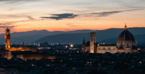
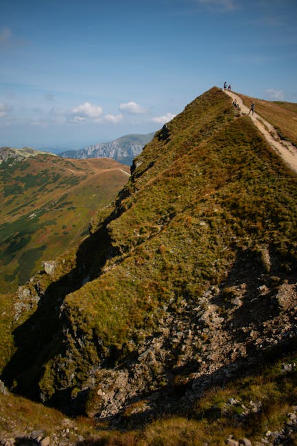
Day 6 — Panoramic ridges and descent to Cortina d’Ampezzo
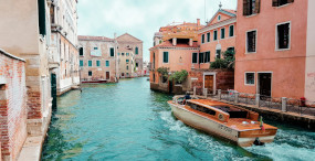
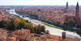
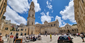
Day six typically brings a gradual descent toward Cortina d’Ampezzo or nearby valleys. Cortina is one of the Dolomites’ most famous alpine towns, offering urban services after several days on the trail. Cortina d’Ampezzo town center — Address: Corso Italia, 1, 32043 Cortina d’Ampezzo (BL). Tourist office hours: 09:00–18:00 in high season. Prices: town restaurants €15–40 per main course; hotels €80–250 per night depending on classification.
Route: from the high ridges follow marked paths descending to Forcella Ambrizzola or Val Travenanzes, then use forest tracks that lead back to Cortina through clearings and hamlets. The town is a good place to resupply, wash gear and — if needed — take a rest day before continuing or heading home.
Click here to book a private lakes tour from Cortina
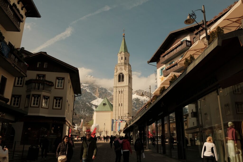
What to do in Cortina: stroll the Centro Storico di Cortina (Corso Italia), buy local specialties at Bottega del Formaggio (Via Roma, 6) or relax in the Parco Naturale delle Dolomiti d’Ampezzo. For museums: the Museo all’Aperto delle 5 Torri (Via Tofana 5) offers WWI exhibits — opening times and fees vary; entry typically €5–10.
Practical tips: if you need gear (shoes, poles, clothing), many shops on Corso Italia rent and repair equipment. Regional buses (Dolomiti Bus) link Cortina to nearby stations (Dobbiaco, Calalzo). Book accommodation in town in advance, as Cortina is very popular in summer.
Day 7 — Final stage: return via Passo Giau or loop to Misurina
The seventh and final day can be a transfer back to your starting point or a last loop to viewpoints you missed, like Passo Giau and Lake Misurina. If you finish at Lake Misurina, enjoy one last view of the Tre Cime from a different angle before descending to your transport. Lake Misurina — Address: Località Misurina, 32041 Auronzo di Cadore (BL). Opening hours: the lake is open year-round; parking and services operate according to season. Parking fee: €10–20.
Optional route: from Cortina take a bus or taxi to Passo Giau (SP638), then hike the ridgelines for one more panoramic day before descending to Misurina or Auronzo to catch a bus/train. Passo Giau is famed for wide views and summer flower meadows; it’s also popular with cyclists and motorcyclists.
Click here to join a guided loop at Passo Giau
Final logistics: plan extra time for transfers depending on your train schedule. The most convenient nearby station is Calalzo di Cadore (stazione), Address: Piazzale Stazione, 32042 Calalzo di Cadore (BL). Dolomiti Bus connects Auronzo/Misurina with Calalzo and Cortina. Inter-valley taxis require prior booking and usually cost €50–120 depending on distance.
End-of-route tips: treat yourself to a big final meal at a rifugio if time allows, double-check your luggage and keep the contact details of your next accommodations. The end of the hike is a great moment to debrief: note difficult sections, leave a thank-you message for refuge hosts and share tips on the refuge page for the hikers who follow.
Conclusion — Practical tips, safety and respect for the territory
Completing the Alta Via in 7 days is an intense and incredibly rewarding adventure. Over these seven stages you’ll cross emblematic scenes — Tre Cime di Lavaredo, Lagazuoi, the Fanes plateau, Cortina d’Ampezzo — while testing your autonomy and mountain skills. Before you leave, always tell a trusted person your itinerary, carry a paper map or GPS with a backup battery, and check the daily weather (recommended sites: ARPAV Veneto, MeteoDolomiti, local refuge bulletins).
Pack appropriate gear: sturdy hiking boots, a windproof and waterproof jacket, a 30–40 L pack, headlamp, survival blanket, first aid kit and enough cash (rifugi sell water but prices can be high — 1.5 L = €3–5). Book your rifugi in advance (phone numbers and addresses listed above), especially from late June to late August. In an emergency call the European medical rescue number 112; refuge keepers are often directly linked to alpine rescue teams (CNSAS).
Respect the mountains: stay on waymarked trails, don’t pick protected flowers, avoid disturbing livestock and pack out your trash. Support the local economy by eating at rifugi (a meal and a night there help maintain trails). Finally, take time to watch the enrosadira at sunrise — it’s one of the Dolomites’ most magical shows.
Whether you’re a photographer, an experienced hiker or a traveler seeking alpine immersion, this 7-day route will leave lasting images and feelings. Good boots, a spirit of adventure and respect for the place: go prepared and return amazed.
Click here to book a photo session with a professional photographer