Introduction
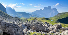
The Dolomites, a UNESCO World Heritage site, are one of the crown jewels of the Italian Alps: sheer limestone faces, endless alpine meadows, and mountain passes that shepherds, soldiers and travelers have used for centuries. For cyclists, this region is a playground—winding roads, singletracks and gravel ribbons that cut through larch forests, alpine lakes and picture-postcard villages. Gravel bikes, that sweet spot between road and mountain biking, are ideal here: they let you reach remote viewpoints without demanding the technical skills of full-on MTB. This guide is aimed at beginners who want to try accessible, safe and spectacular gravel routes in the Dolomites, with clear itineraries, start and end points, mountain huts and sights to visit, plus practical tips to get the most out of each ride.
A few practical realities before you go: altitude, unpredictable weather and loose gravel can catch you off guard. The routes below were selected for their modest relative climbs, wide compact tracks, reasonable signage and regular access to huts or villages for resupply. For each spot we list exact addresses, opening hours and typical prices (in euros) for the tourist services and huts mentioned—handy details for planning a calm, well-prepared gravel day.
Finally, remember the Dolomites are also a cultural destination: tiny alpine chapels, local museums and memorials appear along many routes. Including these stops will enrich your ride—mixing physical effort with a dose of history. Whether you’re on a gravel bike with a light pack and windbreaker or just curious about quiet panoramic roads, these beginner routes are a gentle introduction to the grandeur of the Dolomites.

1) Cortina d’Ampezzo – Passo Falzarego Loop: classic panoramas and mixed surfaces
Quick overview: start and finish in Cortina d’Ampezzo (Piazza Roma), roughly 36 km, total ascent around 650 m, mixed surfaces (paved roads + wide gravel stretches). Skill level: confident beginner on a gravel bike (some descending/tourist traffic sections).
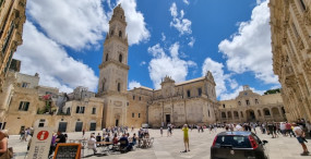
Start point: Piazza Roma, 32043 Cortina d’Ampezzo BL, Italy. Cortina’s main square is an easy meet-up spot with cafes and services. Paid parking: Parcheggio Stazione Centrale, Via Cesare Battisti 1, 32043 Cortina d’Ampezzo BL (typical rate €2–3/hour). If you want a calm start, try to arrive before 09:00 to avoid traffic.
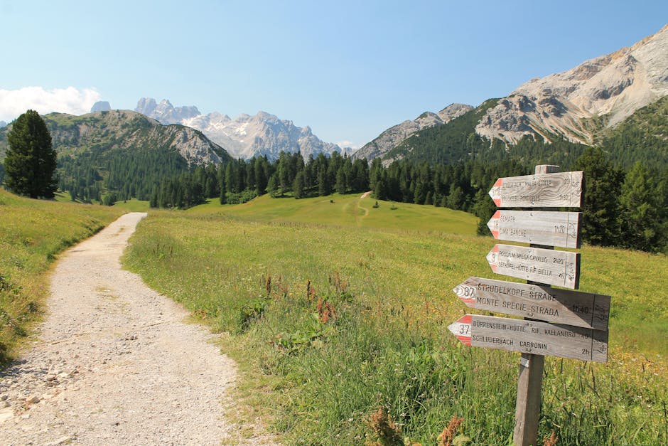
Route: take the SS48 toward Passo Falzarego. After roughly 8 km, at the village of Fiames, turn onto the road up to Passo Falzarego (SP48), which climbs gently. Midway between Forcella Staunies and Passo Falzarego you’ll find wide, compact gravel tracks that work well with 35–45 mm tires. The Falzarego pass (2,105 m) serves up dramatic views of the surrounding massifs and houses the World War I museum (Museo della Grande Guerra 1915–1918).
Museo della Grande Guerra 1915–1918 – Passo Falzarego
- Address: Passo Falzarego, 32020 Livinallongo del Col di Lana BL, Italy
- Opening hours: usually 09:00–17:00 (seasonal, April–October)
- Entrance fee: around €6 for adults, €3 reduced
 Click here to book the Col Giau loop with a guide
Click here to book a private lakes tour from Cortina

Recommended descent: return to Cortina the same way or extend the loop via Val Badia for a longer ride. The road can be busy in summer; take care on paved sections. Suggested stops:
- Rifugio Lagazuoi – great viewpoint and coffee
- Rifugio Falzarego – snacks and toilets
Rifugio Falzarego
- Address: Passo Falzarego, 32020 Livinallongo del Col di Lana BL, Italy
- Opening hours: 08:00–18:00 (varies by season)
- Typical dish: polenta with mushrooms (~€10–12)
Local tips: bring a windbreaker (the pass is often windy), check surface conditions before you set off (maintenance is common), and carry water and energy bars—shops get scarce above 1,800 m. This route blends big alpine views with rideable stretches that are perfect for gravel beginners.
2) Lago di Misurina – Tre Cime di Lavaredo (short option): alpine lakes and iconic peaks
Quick overview: start at Lake Misurina, 22–30 km depending on the variant, ascent roughly 400–600 m, mixed surfaces with wide gravel tracks; ideal for beginners seeking a shorter, highly scenic outing.
Start point: Lago di Misurina parking, SS51, 32041 Auronzo di Cadore BL, Italy. The lakeside lot charges in high season (around €8–12/day). Lake Misurina, with views toward the north face of the Tre Cime di Lavaredo, is an excellent jumping-off point for the ride toward Auronzo di Cadore and the famous Strada delle Tre Cime.
Typical route: from the Lago di Misurina car park follow the SS48 toward Auronzo, then take the private road (Strada Regionale 48) up to Rifugio Auronzo and the Tre Cime parking. For bikes, check local regulations: some sections may be restricted in high season; a quieter gravel alternative follows parallel tracks, especially pleasant early in the morning. The area around the Tre Cime (three emblematic peaks: Cima Grande, Cima Ovest, Cima Piccola) dishes out spectacular views at every turn.
Rifugio Auronzo
- Address: Rifugio Auronzo, Strada Auronzo, 3, 32041 Auronzo di Cadore BL, Italy
- Opening hours: 08:00–20:00 (seasonal, May–October)
- Prices: main meals €12–18, coffee €1.50–3
Practical tips: start early (before 08:00) to beat the crowds; bring a lock if you plan to leave your bike for photos; winds can be strong on the ridgelines—pack a light thermal jacket. The gravel bypass that avoids the main road threads through pine woods, past alpine pastures and small streams—perfect for golden-hour photos.
Click here to book the Tre Cime tour from Misurina

3) Val di Funes (Valley of Funes): gentle Odle spires and pastoral tracks
Quick overview: recommended start near Santa Maddalena (St. Magdalena), 20–35 km depending on the loop, moderate ascent around 300–500 m, mostly compact gravel and farm tracks—very suitable for beginners looking for peace and views of the Odle (Geisler) range.
Recommended start: Church of Santa Maddalena, 39040 Funes (Villnöss), Italy. The tiny church at Santa Maddalena is one of the most photographed scenes in the Dolomites, with the Odle range behind it. Nearby parking: Parkplatz Santa Maddalena, 39040 Funes (free or variable by season).

Route: head out from the village toward the Bosco di Funes, following marked farm tracks and pastoral paths that lead to the Raschötz alpine hut. The profile is steady with no technical climbs—perfect for taking your time to enjoy flower-filled meadows and grazing livestock. Further on, a track climbs to Rifugio Odle / Malga Brogles—a great spot for a traditional lunch.
Rifugio Malga Brogles (Rifugio Brogles)
- Address: Malga Brogles, 39040 Funes (Villnöss), Italy
- Opening hours: typically 10:00–18:00 (seasonal)
- Prices: hot dishes €10–14, drinks €2–4
Local tips: the area is full of non-motorized paths—please respect fences and livestock. Bring bags for your rubbish, and carry a paper map or GPS with offline maps (mobile reception can be patchy). Wear closed shoes for short walks to viewpoints. Evening light turns the Odle into an almost supernatural silhouette—perfect for a last photo stop before heading back.
4) Marmolada and Lago Fedaia: glacier, mountain lake and wide tracks
Quick overview: start at Malga Ciapela, 25–40 km depending on the loop, roughly 600–800 m of ascent, well-compacted gravel tracks with views onto the Marmolada glacier (the « Queen of the Dolomites »). Suitable for beginners in good physical shape who want to get used to longer climbs.
Start point: Malga Ciapela, Piazzale Marmolada, 32020 Malga Ciapela BL, Italy. Parking: Parcheggio Passo Fedaia (rates vary €5–10/day). The approach climbs toward Lago di Fedaia (2,050 m), a glacial lake with turquoise water that often mirrors the Marmolada summit.
Attractions: the « Funivie Marmolada » cable cars can carry you up to Punta Rocca, a starting point for hikers. Practical info:
- Funivie Marmolada (Malga Ciapela)
- Ticket office address: Piazzale Marmolada, 32020 Malga Ciapela BL, Italy
- Hours: typically 08:30–16:30 (seasonal)
- Price: round trip around €35–40 per adult (check season)
Rifugio Pian dei Fiacconi and Rifugio Fedaia are good stops for coffee or a snack after the climb. Tracks around the lake are wide and compact—ideal for gravel—and they offer sweeping sights of the glacier and moraines. If weather or fitness doesn’t allow the full climb, you can shorten the route by using paved roads around the col base.
Practical tips: check glacier conditions and mountain weather (fog and high winds can make the summit dangerous), bring warm layers and sunglasses (intense glare), and obey warning signs near glacial retreat areas. If you plan to mix biking with the cable car, confirm in advance—bike transport may be restricted or incur extra fees.

5) Alta Badia: farm tracks, Ladin villages and local tasting stops
Quick overview: start in Corvara in Badia, 30–45 km depending on the route, moderate ascent around 400–700 m, mainly gravel and small local roads—perfect for beginners who want culture and cycling in one ride.
Start point: Corvara in Badia, Piazza Comunela, 39033 Corvara in Badia BZ, Italy. Corvara is well-equipped with bike shops, cafes and rental services. Example: Bike Rental Corvara, Via Col Alt 10, 39033 Corvara in Badia BZ (usually open 08:00–19:00; gravel bike rental €25–45/day depending on model).
Click here to book an e-MTB outing from Corvara

Route: follow the tracks of Alta Badia toward La Villa and San Cassiano; numerous farm paths link the hamlets, lined by meadows and Ladin farms. Cultural stops include the parish church in San Cassiano and the Ladin Museum Urtijëi (to learn about local Ladin culture). Huts along the way make for pleasant breaks:
- Rifugio Averau – address: Passo Giau, 32020 Colle Santa Lucia BL, Italy. Hours: often 09:00–20:00. Typical dish: canederli (~€10–12).
- Rifugio Piz Arlara – address: La Villa, 39036 Badia BZ, Italy. Hours: variable, mains €10–15.
Local tips: Ladin cuisine is a real reward after a ride—try speck and canederli with a local beer. Secondary roads are usually quiet, but some paved stretches can see tourist traffic; plan your departure around the weather and avoid peak hours (10:00–16:00) in high season. Bring a pump and repair kit—huts don’t always offer bike repairs. Also check public transport options for your return: in summer several buses carry bikes (small surcharge, roughly €3–6 per bike depending on the route).
Conclusion
The Dolomites offer an impressive range of beginner-friendly gravel routes: peaceful loops around alpine lakes, pastoral tracks in Val di Funes, and iconic passes like Passo Falzarego or the approachable climbs to Lago di Fedaia. Each route here was selected for accessibility—compact surfaces, gradual climbs, the presence of places to resupply and overnight—and for the richness of landscapes and cultural heritage you’ll pass through. The precise addresses and practical details (hours, approximate prices in euros) help you plan without surprises, though keep in mind services are seasonal and rates can change.
For a successful stay: start early to enjoy morning light and avoid crowds, check alpine weather, carry a windproof jacket and repair kit, and favor gravel tires of at least 35 mm for comfort on loose surfaces. Respect local rules: some paths may be off-limits to cyclists at certain times or seasons, and caring for pastoral areas and hiking trails is essential to protect this fragile environment. Take time to stop at huts and villages—local food, World War I museums and tiny alpine churches add cultural depth to your ride and turn a simple bike tour into a true Dolomite immersion.
Whether you’re out for a day’s introduction or a multi-day trip, the Dolomites deliver gravel experiences tailored to beginners while promising jaw-dropping panoramas. Bring a good map, a sense of adventure and curiosity: the Queen of the Dolomites is waiting, on gravel-splashed roads bathed in light and history.