Introduction
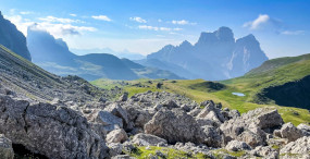
The Dolomites, the iconic mountain range in northeastern Italy, are a cyclist’s playground for every level. A UNESCO World Heritage site, these peaks alternate sheer dolomite walls, verdant alpine meadows, historic passes and weathered mountain villages. Riding here is more than a physical test — it’s a full sensory experience: the scent of conifers in the air, ever-changing panoramas around each bend, and morning and evening light carving the limestone spires into shades of ochre and pink.
This guide walks you through the Dolomites’ top cycling routes, with practical descriptions, exact addresses, opening hours, price indications and local tips so you can plan your ride — whether you’re tackling a day on the Sellaronda, climbing Passo Pordoi, doing a loop around Cortina d’Ampezzo, exploring Alpe di Siusi (Seiser Alm) or ascending toward the Marmolada and Lake Fedaia. Each route includes concrete details: distance, elevation gain, surface type, difficulty level, refuelling spots and transport options to shorten or adapt your itinerary.
Local services matter here: e-bike and road bike rentals, luggage transfers, repair shops and mountain huts open to hungry cyclists. You’ll find exact shop addresses and tourist office details, the opening hours for lifts that shortcut access to some cols, and up-to-date pricing so you can budget your trip. We also share safety tips: when to avoid heavy vehicle traffic, how to gear up for rapid weather changes at altitude, and the local etiquette for mountain roads.
Before you set off, remember one simple rule: respect the mountains and those who live here. The valleys’ economic and cultural roots are alive — farmers, shepherds, guides and small businesses — and your visit will be a pleasure for everyone if you stick to marked routes, keep things clean and stay quiet. Prep your GPS, check road and pass conditions, and go: the Dolomites have a new surprise around every corner.

The Sellaronda: the Classic Tour Around the Sella Massif
The Sellaronda is probably the most iconic cycling route in the Dolomites. This circular circuit goes around the Sella massif, linking four main passes: Passo Sella, Passo Gardena (Grödnerjoch), Passo Campolongo and Passo Pordoi. There are two versions: the « road » variant (fully paved) for road bikes and a « bike » variant for mountain bikes that mixes trails and forest tracks. The loop covers roughly 58–62 km in the classic version, with total elevation gain around 1,800–2,200 m depending on options and direction.
Practical starting point: Val Gardena – Ortisei (St. Ulrich). Tourist office: Ufficio Informazioni e Accoglienza Turistica Ortisei / St. Ulrich, address Via Nives 3, 39046 Ortisei (BZ). Opening hours: 08:30–12:30 / 14:30–18:00 (seasonal variations). Phone: +39 0471 777000. For bike rental: Sport & Bike Hotel Teutschhaus – Bike Rental, Via Meisules 6, 39046 Selva di Val Gardena (BZ), open 08:00–19:00, road bike rental approx. €45–65/day, e-bike €65–95/day.
Typical route (clockwise recommended for less morning shade on north-facing slopes): depart Ortisei toward Passo Gardena (13 km, steady climb), descend to Arabba, then climb to Passo Pordoi (11 km from Arabba), cross Passo Sella and return via Passo Campolongo. The road is paved and well maintained but includes narrow stretches and several tunnels. Tunnels on the Val Badia side can be dark — use lights and a reflective vest if visibility is reduced.
Food and refuelling: mountain huts and restaurants sit atop each pass. Example: Rifugio Maria at Passo Sella, address Passo Sella, 39048 Selva di Val Gardena (BZ), open 09:00–20:00 in season, mountain dishes €10–18; Ristorante Pizzeria La Stua at Passo Pordoi, Passo Pordoi 1, 32020 Livinallongo del Col di Lana (BL), open 08:00–22:00, mains €12–25.
Practical tips: start early to avoid buses and motorhomes in the afternoon, check the weather (fog and storms form fast in summer), and carry an inner tube, pump and a repair kit. To reduce effort, you can use lifts such as the Funivia Pordoi (Funivia Passo Pordoi – Marmolada connection) — departure station: Passo Pordoi, 32020 Canazei (BL). Approximate fare: €10–18 per ascent depending on season and service (check locally).
 Click here to discover the Sellaronda on a half-day tour

Passo Giau and the Cortina d’Ampezzo Loop: Breathtaking Views
Cortina d’Ampezzo, often called the « Queen of the Dolomites, » is the base for a spectacular loop that includes Passo Giau, one of the most photogenic roads in the region. This circuit can be ridden on the road or on gravel, with optional extensions to the Tre Cime di Lavaredo. The Cortina – Passo Giau – Passo Falzarego – Falzarego/Valparola loop generally ranges from 70 to 95 km depending on variations, with elevation gain of 1,800–2,600 m.
Starting point: Tourist Information Cortina d’Ampezzo, address Corso Italia 43, 32043 Cortina d’Ampezzo (BL). Opening hours: 09:00–18:00 (high season), phone +39 0436 8661. Bike services: Bike Service Cortina, Via Marangoi 28, 32043 Cortina d’Ampezzo (BL), open 08:00–19:00, e-bike rental €60–100/day, road bike rental €45–80/day, on-site mechanical service (basic tune-up €25–50).
The standout pass is Passo Giau (2,236 m): the approach has steep stretches (grades over 10%) and rewards you with a vast natural terrace and views of the Cinque Torri and Monte Pelmo. Nearby, the traditional mountain hut Rifugio Col Gallina, Corso d’Appiano 1, 32043 Cortina d’Ampezzo, serves local dishes (open 09:00–20:00 in season, mains €12–20). Descents toward Cortina can be technical: some sections are paved with older surfaces; watch for tight corners and loose gravel.
For photographers and wide-angle lovers, sunrise from the Passo Giau road is unforgettable: rock strata glow pink and the road winds like a drawing across the slope. Access to the Tre Cime di Lavaredo from Cortina is possible via the Misurina road; if you want a shortcut, the Lago di Misurina route offers quieter scenery and a good refuelling stop: Bar Ristorante Lago Misurina, Strada Statale 48, 32041 Auronzo di Cadore (BL), open 08:00–20:00, mains €8–18.
Practical tips: use GPS navigation and downloadable maps (OruxMaps, Komoot) because mobile coverage can be spotty at altitude. Carry spare pads and reliable brakes for long descents. If climbing isn’t your strength, local shuttle buses (SITA) serve cyclists — check schedules and conditions at Cortina’s bus station (Via Lacedel 2).
Click here to book a spectacular loop over Col Giau
Alpe di Siusi (Seiser Alm) and Val Gardena: Wide Tracks and Hanging Meadows
Alpe di Siusi (Seiser Alm) is Europe’s largest high plateau and one of the best spots for relaxed, panoramic cycling. Unlike technical cols, the Seiser Alm offers wide tracks, rideable roads and vistas that seem to stretch forever. The classic loop around Seiser Alm and Val Gardena is perfect for families, gravel riders and e-bikes. It mixes paved sections and compacted paths, with route lengths flexible between 20 and 60 km and generally gentler elevation gains (300–900 m).
Recommended access point: Seiser Alm Bahn / Alpe di Siusi Cable Car, address Sanon 34, 39040 Kastelruth (BZ). Hours: 08:30–19:00 (seasonal). Round-trip cable car fare for a bicycle: about €12–18 per person (check locally). For bike emergencies: Bike Service Ortisei – Cicli Simon, Via Rezia 1, 39046 Ortisei (BZ), open 08:00–18:00, e-bike rental €55–85/day.
The typical route starts with the cable car ride from Ortisei up to Alpe di Siusi or from Siusi allo Sciliar. Once up top, trails wind between alpine huts like Baita Sunela and Rifugio Bolzano, where you can sample Tyrolean specialties: canederli (€8–12), smoked speck (€6–10) and strudel (€4–6). Trails are well signed, but a good GPS or map helps choose variants depending on the wind — the plateau is exposed and alpine wind can make some sections harder.
Seiser Alm is particularly e-bike friendly: batteries let you cover long distances and enjoy the views without pushing too hard. For a cultural stop, visit the Museum Gherdeina (Ortisei), Via Meisules 15, 39046 Ortisei (BZ), open 10:00–17:00, tickets €6–10 depending on exhibits. The route then descends back into Val Gardena, where woodcarving workshops often show demonstrations (typical example: Atelier Lorenz, Via Runch 6, 39046 Ortisei, visits by appointment).
Practical tips: in summer bring sunscreen and good sunglasses — the plateau reflects a lot of light. Watch for herds and cows with bells: be courteous (slow down, pass calmly). If the weather turns, descend to the valley where more services are available. If you’re traveling by train/bus, local SAD/Trentino Trasporti lines serve the valley; check bike carriage rules (often require reservation).
Click here to book a photo session on Alpe di Siusi
Marmolada, Lake Fedaia and the Glacier: a Historic, Demanding Climb
Marmolada, nicknamed « the Queen of the Dolomites, » is the range’s highest peak and still shows a glacier visible from Passo Fedaia and the nearby lake (Lago di Fedaia). The classic climb starts in Malga Ciapela and heads to Passo Fedaia (2,057 m) along the lakeshore, with dramatic views of Marmolada’s north face and its glacier. It’s a demanding route for experienced cyclists: about 14–16 km of climbing from Malga Ciapela, with steep sections and exposed, windy stretches.
Starting point: Malga Ciapela, address Via Marmolada 1, 32020 Rocca Pietore (BL). For information: Ufficio Turistico Rocca Pietore, Via Pordoi 6, 32020 Rocca Pietore (BL), seasonal hours, phone +39 0437 986041. Historic cable car: Funivia Marmolada – Punta Rocca, lower station at Malga Ciapela, address Via della Marmolada 1, 32020 Malga Ciapela (Rocca Pietore). Hours and fares vary; pedestrian ascent approx. €12–25, bikes may be charged extra (check online).
Lake Fedaia (Lago di Fedaia) is a nearly mandatory stop: its surface mirrors the Marmolada wall, making for memorable photos. From there you can visit the Great War museum (Museo della Grande Guerra Marmolada 1915–1918) at Passo Fedaia. Address: Passo Fedaia, 32020 Rocca Pietore (BL). Opening hours: 09:00–17:00 (seasonal), ticket approx. €7–10 per person. The museum recounts high-altitude warfare and the installation of cableways and galleries on the glacier.
Refuelling: lakeside mountain restaurants serve polenta, cheese dishes and pasta (€10–18). Example: Ristorante Lago Fedaia, Strada Statale 641, 32020 Rocca Pietore (BL), open 08:00–20:00 (season), mains €12–22. Road conditions can be affected by rockfall and winter closures often last into spring; check local information before you ride.
Practical tips: the route is exposed — pack windproof and waterproof layers even in summer. Oxygen levels drop slightly on the climb — hydrate frequently. Marmolada also draws motorbikes: hold your line in corners and use a short bell or verbal signal to make your presence known if needed. If you don’t want to climb the entire way, shuttles run up to Malga Ciapela from Canazei or Rocca Pietore.

Tre Cime di Lavaredo and Lake Braies: Exceptional Routes for Gravel and MTB
The Tre Cime di Lavaredo (Drei Zinnen) and Lago di Braies (Pragser Wildsee) area offers some of the Dolomites’ most photogenic routes. These roads are ideal for gravel and mountain bikes, mixing forest tracks, secondary roads and short paved stretches. The loop around Tre Cime, including a tour of the massif, is flexible: a short loop of 30–45 km or a more demanding circuit of 60–90 km if you add Lago di Braies.
Main access: Tre Cime Visitor Centre / Auronzo di Cadore, address Via Monte Piana 8, 32041 Auronzo di Cadore (BL). Hours: 09:00–17:00 (high season), phone +39 0435 3633. Popular parking and start point: the Lago di Misurina car park, Strada Statale 48, 32041 Auronzo di Cadore (BL), paid parking (approx. €6–10/day depending on season).
The climb to Rifugio Auronzo (Rifugio Auronzo alle Tre Cime), address Rifugio Auronzo, 32041 Auronzo di Cadore (BL), is accessible by paved road from Misurina with a toll (approx. €30–35 per car; cyclists are generally allowed but check seasonal restrictions). The view from the top is spectacular: the three iconic peaks rise above a lunar-like plateau — a perfect photo stop.
Lago di Braies, parking address Strada per Braies 1, 39030 Braies (BZ), is extremely popular: the full lakeside walk is about 3.5 km and fits easily into a bike outing. Watch for opening hours and traffic restrictions in high season (parking fills up early). The mountain hut Rifugio Biwak al Lago di Braies offers snacks and drinks (open 09:00–18:00 seasonally, prices €4–12).
Practical tips: because these areas attract many visitors, start early to avoid crowds and enjoy the best light for photos. Trails around Tre Cime include technical gravel and rocky sections: a mountain bike or gravel bike with wide tyres and good suspension is recommended. Always obey signage and protected-area rules — some sections are pedestrian-only during peak season.
Click here to discover the Tre Cime refuges with a guide
Click here to explore Misurina by e-bike with lunch included

Conclusion
The Dolomites offer a variety of cycling routes to suit every appetite: from the intense alpine loop of the Sellaronda to the gentle pastures of Alpe di Siusi, from the stunning panoramas of Passo Giau around Cortina d’Ampezzo to the icy challenges of Marmolada, and the picture-perfect itineraries around Tre Cime and Lago di Braies. Each route has its own character — some will test your legs and mind, others invite you to slow down and soak it in — but all reward the rider with unforgettable views, hearty mountain food and warm local hospitality.
Logistics: book bike rentals and accommodation ahead in high season (July–August), always check lift hours and road status (traffic, works, winter closures). Local tourist offices (Cortina d’Ampezzo, Val Gardena, Alta Badia, Auronzo di Cadore) are excellent sources for updates and event info. For gear, bring a good pair of gloves, a windproof jacket, an offline-capable GPS and a repair kit.
Respect and safety: ride courteously — let faster vehicles pass, announce your overtakes and slow down around herds and pedestrian areas. Remember the mountains are fragile: leave no trace, use recycling points and avoid cutting vegetation. In case of an accident or medical emergency, dial the European emergency number 112; mountain rescue is organized but response times vary depending on access.
Whether you come for the sport, the photography, the silence of the alpine meadows or the cultural discoveries, the Dolomites will captivate you. Take a notebook to jot down favourite stages, carry local maps to boost your safety and, above all, allow time to savour each summit, hut and encounter. Safe travels and happy pedaling — the Dolomites’ roads are waiting.